Watershed 6: Nanaimo River and South Area A
This watershed area contains Cedar, Duke Point, and portions of Electoral Areas A and C, and is the largest watershed in the RDN. It starts at Fourth Lake and follows Nanaimo River down to the estuary across from downtown Nanaimo. The upper watershed is mainly unpopulated forestry land. The southern portion of the watershed is primarily rural with areas of agriculture, urbanization and industrial activity.
Surface Water
Watershed 6 includes the Nanaimo lakes, the Nanaimo River, Haslam Creek and Quennell Lake as well as many other streams and small lakes. The Nanaimo River is the City of Nanaimo's drinking water source and is also used widely by the community for recreation such as swimming and kayaking. The river drains into Vancouver Island's largest estuary - a highly productive biological area, sandwiched by Duke Point to the East and downtown Nanaimo to the West. In dry summer months, groundwater from local aquifers flows into the Nanaimo River to help maintain flow even when there is no rain or snow melting. This is called 'base flow'. Base flow is particularly important for maintaining estuary health. The major water user in this region is the Harmac pulp mill.
There are some concerns that small lakes in the Yellow Point area may face eutrophication, as excessive nutrients from failing septic systems and fertilizers cause excessive plant growth that takes oxygen from fish.
Aquifers
This area contains the upper and lower Cassidy aquifers (upper - 161, lower - 160), the Yellow Point aquifer (162) and aquifers 163 (South Wellington) and 165 (Cedar area). The Cassidy and Yellow Point aquifers are unique and very different groundwater systems. The upper Cassidy aquifer (161) is a highly productive and highly vulnerable sand and gravel aquifer. We must take great care to protect groundwater quality by properly managing any potential sources of contamination on the surface of this highly vulnerable aquifer. The Yellow Point aquifer is composed of compacted mud and sandstone layers known as the "Nanaimo Group". This is the same type of rock that is found on Gabriola Island and the Gulf Islands. Yellow Point aquifer is less vulnerable than the Cassidy aquifer, but is also a very 'low producing aquifer' with 'low permeability' and 'low porosity'. That means that this type of rock has a limited ability to store and produce water and that when limited water is removed from this aquifer it can take a long time to recharge, or 're-fill'.
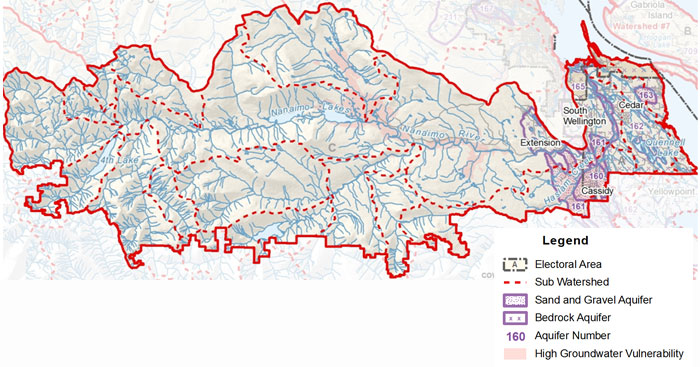
- Click Here to download a fullsize version of this map (3.3MB)
- Click Here to download the RDN PHASE 1 WATER BUDGET REPORT for WR6 - NANAIMO RIVER (2013) or go to www.rdnwaterbudget.ca