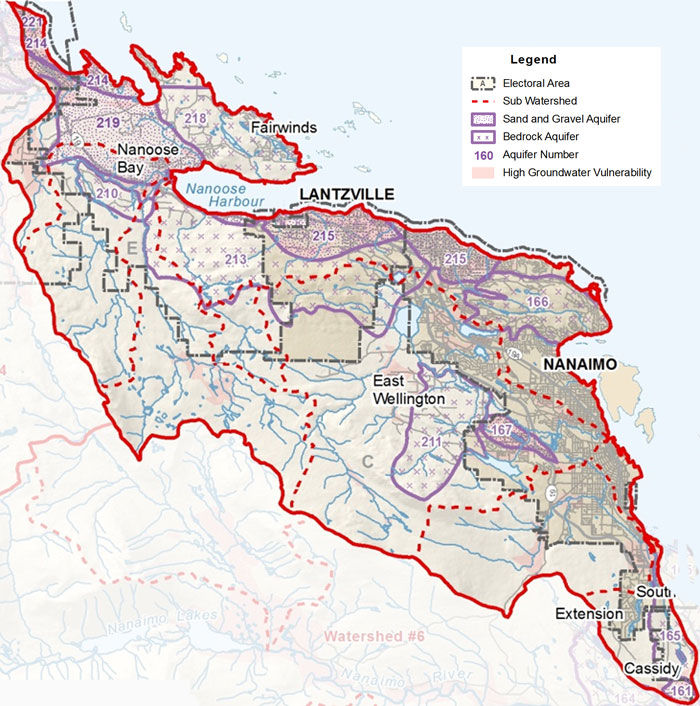
Watershed 5: Nanoose to South Wellington
This watershed area spans from Nanoose in the north, down to South Wellington in the south. The highest point in this area is Mount Benson, at an elevation of 1023 m (3356 ft). The watershed area contains the District of Lantzville, almost the entire City of Nanaimo, and parts of Electoral Areas E, C, A, and F. This watershed area has a relatively high population density due to the large number of residents in and around the City of Nanaimo.
Surface Water
This watershed encompasses an area of about 100 square kilometres, consisting of 26 streams, 16 tributaries, and 8 lakes, including the Millstone River, Departure Bay Creek and Enos Lake. Enos Lake in Nanoose Bay is home to a rare, endangered fish - the Limnetic Enos Lake Stickleback. The Millstone is a highly urbanized 14 km river that runs from Brannen Lake into the City of Nanaimo's Inner Harbour. This waterway has been greatly impacted by urban development. In nature, when rain falls, it slowly trickles through forests and undergrowth gently towards the stream over several days. In a City, when rain falls, it hits the pavement and is quickly rushed into the nearest storm drain. Along the way, it picks up harmful chemicals such as oil from cars, rubber from tires, and even garbage. When this 'dirty' water rushes into the stream, it is flowing far too quickly and often scours the stream bed and banks, destroying fish habitat. In the City, it is particularly important that we take care to limit paved surfaces on our properties where possible, and remember that anything we put down a storm drain ends up in a river.
Groundwater
Many aquifers in this area are bedrock aquifers made of a type of rock known as the 'Nanaimo Group', which is a blanket of compacted mud and stone layers, about six kilometers thick, deposited years ago when the east coast of Vancouver Island was buried under water. The rock contains coal deposits, fossils, and cracks or fractures that can hold water. These fractures are what make up our bedrock aquifers. Many of these fractures cannot hold a lot of water and when that limited water is removed it can take a long time to recharge or 're-fill'. Communities such as Lantzville, Nanoose, and Benson Meadows that rely on these bedrock aquifers for their water supply have to be particularly careful to conserve water, especially in dry summer months. The RDN is working with the Ministry of Environment to monitor water levels in this area to better understand what is happening under the ground. One example of this is the new monitoring well in the Benson Meadows park.
- Click Here to download a fullsize version of this map (2.6MB)
- Click Here for detailed information on the City of Nanaimo's watersheds.
- Click here for the Phase 1 Water Budget Report for Water Region 5 - South Wellington to Nanoose.
- Click Here to download the RDN PHASE 1 WATER BUDGET REPORT for WR5 - NANOOSE TO SOUTH WELLINGTON (2013) or go to www.rdnwaterbudget.ca