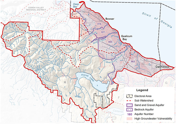
Watershed 1: Qualicum, Nile, Thames & Rosewall
This watershed area goes from Deep Bay in the north, down to Dashwood in the south, and as far west as the Regional District boundary. This primarily rural watershed area includes most of Area H, including Qualicum Bay and Bowser, as well as small parts of Electoral Areas F and G. This watershed area is extremely important for many different species of fish.
Surface Water
This watershed area includes the Qualicum River watershed as well as the smaller watersheds of Rosewall Creek, Thames Creek, and Nile Creek, which all drain into the Strait of Georgia. The Big Qualicum River is the biggest waterway, flowing 11km northeast from its source at Horne Lake, to the Strait of Georgia. The river's name comes from that of the Qualicum people. The DFO runs a hatchery on the Qualicum River and employs a number of natural and artificial enhancement techniques to increase populations of Pacific salmon and steelhead trout. All species of Pacific salmon return to Big Qualicum as do steelhead and cutthroat trout. Chum represent the highest production followed by good populations of coho and chinook.
Aquifers
The aquifers in the populated coastal regions of this watershed area are productive sand and gravel aquifers. The mapped aquifers in this region include aquifers 416, 421, 665, and part of 662. Many regions of these sand and gravel aquifers are highly vulnerable to surface contamination, so it is important that we are careful what we do on the land, in order to protect the quality of water in the ground. There is an observation well in aquifer 416 (Deep Bay, Bowser) that monitors water levels throughout the year. At this point, water levels in the aquifer appear to be following precipitation trends and there is no reason to indicate that there are any issues with water supply.
Limestone features north and west of the Horne Lake area have helped form the famous Horne Lake caves. The limestone forms 'karst' topography, which is created when water dissolves rock, to form caves and underground tunnels. Here, water underground flows in subterranean rivers or lakes.
- Click Here to download a fullsize version of this map (2.8MB)
- Click Here to download the RDN PHASE 1 WATER BUDGET REPORT for WR1 - BIG QUALICUM (2013) or go to www.rdnwaterbudget.ca