Watershed 2: Little Qualicum River
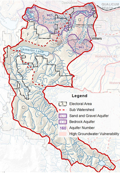 The Little Qualicum River flows north east from the highest point in the watershed in Labour Day Lake on Mount Arrowsmith towards Cameron Lake and down the Little Qualicum River to the Straight of Georgia.The highest point in this watershed is Mount Arrowsmith, at an elevation of 1819 metres. The drainage area of the Little Qualicum River, including Whisky Creek, is 251 Km2 (96.9 mi2). It contains parts of Electoral Areas F, G, and H.
Surface Water
The Little Qualicum River has been designated by the Ministry of Environment as a 'Sensitive Stream' that requires special management attention, under the Fisheries Protection Act, because of risk to fish populations due to inadequate water flows and other habitat concerns. It is also designated as a 'community watershed' because a local community has a license on it to supply drinking water. This watershed is extremely important for many different species of fish, including a sizable run of steelhead and a sea-run cutthroat trout fishery. Rainbow and some brown trout are present, with chinook salmon runs in the fall . Whiskey Creek and Kinkade Creek also flow into the Little Qualicum River. Cameron Lake's outlet into the Little Qualicum River has been controlled since 1978.
Aquifers
This watershed area includes aquifers 661, 664, and part of 662 and 663 which are generally productive sand and gravel aquifers. Many regions of these sand and gravel aquifers are highly vulnerable to surface contamination, so it is important that we are careful what we do on the land, in order to protect the quality of water in the ground.
- Click Here to download a fullsize version of this map (3.0MB)
- Click Here to download the RDN PHASE 1 WATER BUDGET REPORT for WR2 - LITTLE QUALICUM (2013) or go to www.rdnwaterbudget.ca